


Listar por Entidad UPV "Universitat Politècnica de València. Departamento de Ingeniería Cartográfica Geodesia y Fotogrametría - Departament d'Enginyeria Cartogràfica, Geodèsia i Fotogrametria"
RiuNet: Repositorio Institucional de la Universidad Politécnica de Valencia
- RiuNet repositorio UPV
- :
- Listar por Entidad UPV
JavaScript is disabled for your browser. Some features of this site may not work without it.
Buscar en RiuNet
Listar
Mi cuenta
Ayuda RiuNet
Admin. UPV
Listar por Entidad UPV "Universitat Politècnica de València. Departamento de Ingeniería Cartográfica Geodesia y Fotogrametría - Departament d'Enginyeria Cartogràfica, Geodèsia i Fotogrametria"
Mostrando ítems 21-40 de 1156
-
 Quintanilla García, Israel; Vera-Vélez, Norberto; Alcaraz Martínez, Pablo; Vidal Ull, Jordi; Fernández Gallo, Beatríz (MDPI AG, 2021-02-17)[EN] On the one hand, Unmanned Aircraft Systems (UASs) have experienced great applicability surge in the recent years, arising as a promising technology with a wide field of use. On the other hand, healthcare, a critical ...
 -
 Viñals Blasco, Mª José; Martínez, I.; Abdennadher, A.; Teruel Serrano, Mª Dolores (WIT Press, 2014)The increase in cultural tourism has revealed the vulnerability of the heritage resources during the phase of tourism exploitation and, thus, the need to set limits and to establish visitor management tools to ensure the ...
 -
 Lerma García, José Luis; Cabrelles López, Miriam (Wiley: 12 months, 2007)[EN] Radial and decentring distortion parameters have long been reported as fundamental elements in camera calibration, especially in digital close range photogrammetry. This paper reports on an investigation for the ...
 -
 Carbonell-Rivera, Juan Pedro; Estornell, Javier; Ruiz, Luis; Abad, Alfonso; Felten, Bettina; Torralba, Jesús (Editorial Universitat Politècnica de València, 2021-10-01)[EN] In recent years, Remote Sensing (RS) and its derived products have been used as a key tool for the detection, monitoring, management and future use of Marginal Lands (ML). Currently, there is no single, universally ...
 -
González Aguilera, Diego; Rodríguez Gonzálvez, Pablo; Hernández López, David; Lerma García, José Luis (Elsevier, 2012-09)This paper presents a new robust approach to integrate intensity and visible images which have been acquired with a terrestrial laser scanner and a calibrated digital camera, respectively. In particular, an automatic and ...
-
 Palomar-Vázquez, Jesús; Pardo Pascual, Josep Eliseu; Sebastiá Tarín, Laura; Recio Recio, Jorge Abel (Maney Publishing, 2012-05)In this article, a technique towards the generation of hybrid raster-attributes map for use in mobile devices is described. Our solution is based on coding the map attributes within an image using RGB values. The designed ...
 -
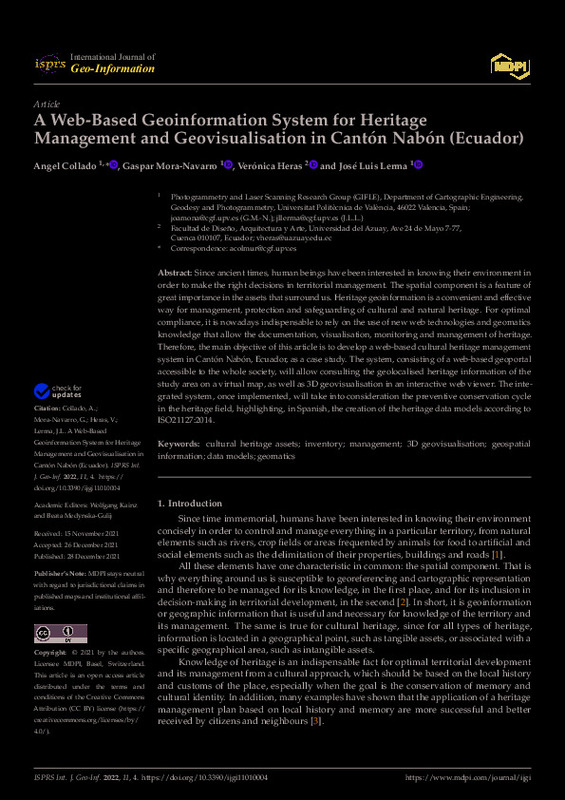 Collado, Angel; Mora-Navarro, Gaspar; Heras, Verónica; Lerma, José Luis (MDPI AG, 2021-12-28)[EN] Since ancient times, human beings have been interested in knowing their environment in order to make the right decisions in territorial management. The spatial component is a feature of great importance in the assets ...
 -
Arroquia-Cuadros, Benjamin; Marqués-Mateu, Ángel; Sebastiá Tarín, Laura; Fdez-Arroyabe, Pablo (Springer-Verlag, 2021-08)[EN] Data are the fundamental building blocks to conduct scientific studies that seek to understand natural phenomena in space and time. The notion of data processing is ubiquitous and nearly operates in any project that ...
-
 Navarro Tarin, Santiago; Lerma García, José Luis (Elsevier, 2016-11)[EN] Image-based mapping solutions require accurate exterior orientation parameters independently of the cameras used for a survey. This paper analyses the inclusion of up to two stereo-based geometric constraints in the ...
 -
 Hadás, Edyta; Estornell Cremades, Javier (Taylor & Francis, 2016)[EN] The aim of this study was to compare geometric parameters of olive trees (tree height, crown base height, crown diameters, crown area), using LiDAR data of different densities: 0.5, 3.5 and 9 points m(-2). Two strategies ...
 -
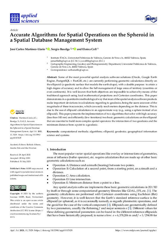 Accurate Algorithms for Spatial Operations on the Spheroid in a Spatial Database Management System Martínez Llario, José Carlos; Baselga Moreno, Sergio; Coll-Aliaga, Eloína (MDPI AG, 2021-06)[EN] Some of the most powerful spatial analysis software solutions (Oracle, Google Earth Engine, PostgreSQL + PostGIS, etc.) are currently performing geometric calculations directly on the ellipsoid (a quadratic surface ...
 -
Pinedo Reyes, Joaquín (Universitat Politècnica de València, 2019-12-26)[ES] Trabajos de diseño de viales de carretera para mejoras de acceso de vehículos rodados a vertedero de basuras.
-
 Sánchez Lopera, José; Lerma García, José Luis (Grupo de Tecnologías de la Información Geográfica, Asociación de Geógrafos Españoles, 2012-03)[EN] This paper presents a methodology to automatically update urban cartography using LiDAR (Light Detección And Ranging) data and GIS (Geographic Information Systems). It is worth having access to large scale urban ...
 -
Adán Silvestre, Francisco Javier (Universitat Politècnica de València, 2019-09-02)[ES] Este proyecto consta del diseño de un geoportal multiplataforma que contiene múltiples capas comprendiendo gran parte de la información geográfica del municipio de Bétera. Se ha diseñado un geoportal web en el que ...
-
López Gómez, Miriam (Universitat Politècnica de València, 2016-12-01)[EN] This Master's Thesis consists of the redaction of the necessary documentation for the Heliport of the Hospital Universitario Insular in Las Palmas for obtaining the authorization of the AESA as a Heliport for nocturnal ...
-
 Iborra-Fabra, Ramon; Femenia-Ribera, Carmen; Mora-Navarro, Gaspar (Editorial Universitat Politècnica de València, 2021-10-01)[EN] Disagreements between public administrations and neighbors in areas near the territorial boundaries between municipalities have increased as the urban development of municipalities increases. Not surprisingly, in ...
 -
 Ferrer Calatayud, David (Universitat Politècnica de València, 2015-07-17)[ES] La finalidad del proyecto es la de diseñar y desarrollar un sistema emebebido compuesto por un microordenador y una IMU que permita obtener lecturas de movimientos inerciales. Una IMU es un dispositivo formado por ...
 -
 Femenia-Ribera, Carmen; Mora Navarro, Joaquin Gaspar; Martínez Llario, José Carlos (MDPI AG, 2021-01)[EN] A necessary and effective coordination between cadastre and land registry has always existed in Spain, but the difficulties have only been specifically addressed in the last few years. The aim of this study is to ...
 -
 Marqués Pérez, Inmaculada; Mora Navarro, Joaquin Gaspar; Pérez-Salas Sagreras, Jose Luis; Velilla-Torres, Joan Manuel; Femenia-Ribera, Carmen (Maney Publishing, 2018)[EN] Quantifying the effect of location on land values can be done by designing a location factor which considers the most relevant aspects that may influence this value such as proximity to large cities, the population ...
 -
 Balsa Barreiro, José; Avariento Vicent, Joan Pere; Lerma García, José Luis (Academic Journals, 2012-08)The point density is a preeminent parameter on airborne laser scanner surveys. It is not only related to accuracy but costs and savings. The lack of uniformity of the point density across the survey is well-known in ...
Mostrando ítems 21-40 de 1156

Universitat Politècnica de València. Unidad de Documentación Científica de la Biblioteca (+34) 96 387 70 85 · RiuNet@bib.upv.es
El contenido de este sitio está bajo una licencia Creative Commons Reconocimiento – No Comercial – Sin Obra Derivada (by-nc-nd), salvo que se indique lo contrario.
Los metadatos de este sitio están bajo una licencia Dominio Público.
