


Listar por palabra clave "Cartography"
RiuNet: Repositorio Institucional de la Universidad Politécnica de Valencia
- RiuNet repositorio UPV
- :
- Listar por palabra clave
JavaScript is disabled for your browser. Some features of this site may not work without it.
Buscar en RiuNet
Listar
Mi cuenta
Ayuda RiuNet
Admin. UPV
Listar por palabra clave "Cartography"
Mostrando ítems 21-40 de 96
-
 Caiza, Lorena; Zegarra, Gabriela; Navarro, Estefania; Alvarez, Flor (Editorial Universitat Politècnica de València, 2021-10-01)[EN] The spatio-temporal variability of vegetation in urban areas is one of the current concerns about climate variability events such as extreme temperature changes and flooding, coupled with the forecast that 70% of the ...
 -
 Espigares Rooney, Blanca (Universitat Politècnica de València, 2014-05-15)[EN] Architectural drawing has always been used as a tool of expression as well as for study and exploration. The aim of this research work is to find an approach to chart chorographies of the historic urban landscape of ...
 -
 Roig Muñoz, Javier (Universitat Politècnica de València, 2021-01-07)[ES] El objetivo de este proyecto es generar, adaptar y estructurar la base cartográfica del modelo del riesgo de emisiones de gases de efecto invernadero del proyecto europeo Interreg SUDOE REMAS. Se elaborará una ...
 -
 Antivil Marinao, Wladimir; Flores Chávez, Jaime (Universitat Politècnica de València, 2023-07-24)[ES] El Estado de Chile, durante la segunda mitad del siglo XIX, procede a radicar a las diferentes agrupaciones mapuches que quedaban en el territorio de la actual Araucanía. Posteriormente, en los años 1916 y 1917, el ...
 -
 López Sánchez, Marina; Linares Gómez del Pulgar, Mercedes; Tejedor Cabrera, Antonio (Universitat Politècnica de València, 2022-03-24)[EN] The heritage landscapes located in the vicinity of the cities constitute complex territorial palimpsests. The landscape projects in these areas aim, among other aspects, to improve its heritage intelligibility by ...
 -
 Sosa-Avaro, Leandro; Justel, Ana; Molina, Iñigo (Editorial Universitat Politècnica de València, 2021-10-01)[EN] The frequency and intensity of extreme worldwide weather events have increased in recent decades, causing enormous economic losses. In Argentina, in the 2017-2018 agricultural season, more than 200 million dollars ...
 -
 García-Lanchares, Carlos; Marchamalo, Miguel; Sancho, Candela (Editorial Universitat Politècnica de València, 2021-10-01)[EN] This communication presents the formulation and first steps of an Industrial PhD project, developed in the frame of the “Kuk ahpán” project (Spanish National R&D Plan, 2019-2022) that aims to understand, monitor and ...
 -
 Castelló Martínez, Adrián (Universitat Politècnica de València, 2020-03-26)[EN] Taking the previous results in the field of the generalization of railways as base, in this thesis has been developed a new system of generalization of railways, using the theory of graph analysis, in combination with ...
 -
 Roch Talens, Ausias (Universitat Politècnica de València, 2020-09-08)[CA] La següent dissertació té com a objectiu realitzar una classificació dels compostos químics que es troben en la superfície del planeta Mart. Les dades utilitzades en este treball han estat preses pels ròvers i sondes ...
 -
 Escayo, Joaquín; Fernández, José; Hu, Zhongbo; Camacho, Antonio; Samsonov, Sergey; Prieto, Juan; Tiampo, Kristy; Palano, Mimmo; Mallorquí, Jordi (Editorial Universitat Politècnica de València, 2021-10-01)[EN] The island of La Palma is one of those with the highest potential risk in the Canary archipelago, therefore it is important to carry out an in-depth study to define its state of volcanic activity. This has been done ...
 -
 De la Vega-Panizo, Rogelio; Garmendia, Andrea; Paredes, Carlos; Ropero, Miguel (Editorial Universitat Politècnica de València, 2021-10-01)[EN] Deception Island is an active volcano on which two Antarctic bases are located, the Spanish Antarctic Base Gabriel de Castilla and the Deception Antarctic Base, with scientific personnel working there during the ...
 -
 Astudillo-Ortega, Susana; Vazquez, Antonio (Editorial Universitat Politècnica de València, 2021-10-01)[EN] In metropolitan areas, daily mobility for work reasons, study, daily procedures, leisure and free time acquires great importance. This research aims to build a methodology for the analysis of daily mobility based on ...
 -
Belda Ribera, Miguel (Universitat Politècnica de València, 2020-09-29)[ES] Los incendios forestales son la principal causa de degradación del medio natural en la región mediterránea, junto a las plagas y a otras perturbaciones derivadas del cambio climático, causando gran impacto sobre el ...
-
 Urrea Montoya, Michael (Universitat Politècnica de València, 2022-05-31)[EN] Maps have witnessed our passage through the world, as well as our ambitions for knowledge, power and transcendence. They have also guided our species on a journey through space and time, being an essential tool for ...
 -
 Llopis Verdú, Jorge; Serra Lluch, Juan; Torres Barchino, Ana María (Università di Bologna, 2019-06)[EN] The use of diagrams is a graphic strategy, which, given the need to establish interpretative mechanisms that help us appreciate how a structure of such great formal complexity operates, has been used for some time to ...
 -
Pedrola Tortajada, Andreu (Universitat Politècnica de València, 2019-12-26)[CA] El present document es crea amb la finalitat d’apropar als professionals de la geomàtica, així com d’altres àmbits (medi ambient, urbanisme, etc.), els avantatges i les facilitats per crear i compartir noves dades ...
-
 Garrido, José; Marqués, Ángel; Martín, Ángel; Llorens, José (Editorial Universitat Politècnica de València, 2021-10-01)[EN] Current trends in urban lighting design are focused on factors such as energy efficiency, environmental sustainability, and multi-service effectiveness. As in most urban facilities, geographic location is a key ...
 -
 Lapeña Gallego, Gloria; Ortuño Mengual, Pedro (Editorial Universitat Politècnica de València, 2017-10-23)[EN] From the seventies, the historians have brought their research closer to the needs of a plural society. The artist, too, adopts a critical stance against the unequal treatment of the various identities throughout a ...
 -
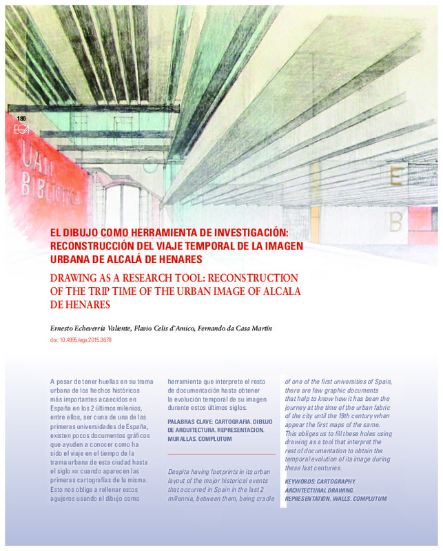 Echeverría Valiente, Ernesto; Celis d'Amico, Flavio; da Casa Martín, Fernando (Universitat Politècnica de València, 2015-06-22)[EN] Despite having footprints in its urban layout of the major historical events that occurred in Spain in the last 2 millennia, between them, being cradle of one of the first universities of Spain, there are few graphic ...
 -
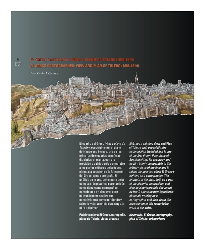 Calduch Cervera, Juan (Editorial Universitat Politècnica de València, 2012-06-30)[EN] El Greco¿s painting View and Plan of Toledo and, especially, the outlined plan included in it is one of the first drawn floor plans of Spanish cities. Its accuracy and quality is only comparable to the military plans ...
Mostrando ítems 21-40 de 96

Universitat Politècnica de València. Unidad de Documentación Científica de la Biblioteca (+34) 96 387 70 85 · RiuNet@bib.upv.es
El contenido de este sitio está bajo una licencia Creative Commons Reconocimiento – No Comercial – Sin Obra Derivada (by-nc-nd), salvo que se indique lo contrario.
Los metadatos de este sitio están bajo una licencia Dominio Público.
