


Listar por palabra clave "LiDAR"
RiuNet: Repositorio Institucional de la Universidad Politécnica de Valencia
- RiuNet repositorio UPV
- :
- Listar por palabra clave
JavaScript is disabled for your browser. Some features of this site may not work without it.
Buscar en RiuNet
Listar
Mi cuenta
Ayuda RiuNet
Admin. UPV
Listar por palabra clave "LiDAR"
Mostrando ítems 61-73 de 73
-
 Martínez García, Iván (Universitat Politècnica de València, 2015-05-25)[ES] Durante la realización de este proyecto hemos sido capaces de realizar dos modelos de combustible de las zonas de estudio, separando de una forma aceptable las zonas, de mayor o menor densidad de vegetación y árboles, ...
 -
 Campoy Ungria, Jose Manuel (Universitat Politècnica de València, 2015-12-21)[EN] The existence of a visibility that is appropriate to the actual operating conditions is a sine qua non to achieve a safe geometric design. The sight distances required in driving tasks, such as decision-making, stopping, ...
 -
Campoy Ungria, Jose Manuel; García García, Alfredo; Pérez Zuriaga, Ana María; Camacho Torregrosa, Francisco Javier (Asociación Técnica de Carreteras, 2012)[EN] Sight distances are one of most important parameter on new highways geometric design for stopping, passing or crossing maneuvers; however, its measurement and verification on existing roads, is a difficult and expensi-ve ...
-
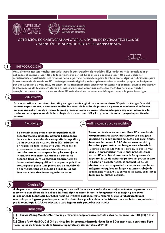 Shang, Fangjian (Universitat Politècnica de València, 2021-10-07)[ES] La tecnología de escaneo láser 3D puede obtener rápidamente coordenadas 3D precisas de la superficie delmodelo, pero también tiene algunas deficiencias para la construcción de modelos 3D. En primer lugar, la información ...
 -
Navarro Cerrillo, Rafael M.; Campo García, Antonio Dámaso del; Ceacero Ruíz, Carlos Juan; QUERO, JOSÉ LUIS; Hermoso de Mena, Javier (Elsevier, 2014-06)[EN] Pine seedling survival and growth in eastern Spain have often been related to site preparation, planting date and seedling stock. However, in spite of the acknowledged importance of spatial heterogeneity in seedling ...
-
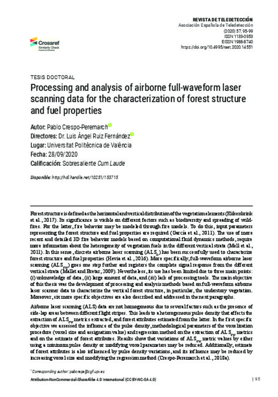 Crespo-Peremarch, P.; Ruiz, L. A. (Universitat Politècnica de València, 2020-12-28)[EN] This PhD thesis addresses the development of full-waveform airborne laser scanning (ALSFW) processing and analysis methods to characterize the vertical forest structure, in particular the understory vegetation. In ...
 -
 Crespo Peremarch, Pablo (Universitat Politècnica de València, 2020-10-30)[ES] Esta tesis aborda el desarrollo de métodos de procesado y análisis de datos ALSFW para la caracterización de la estructura vertical del bosque y, en particular, del sotobosque. Para responder a este objetivo general, ...
 -
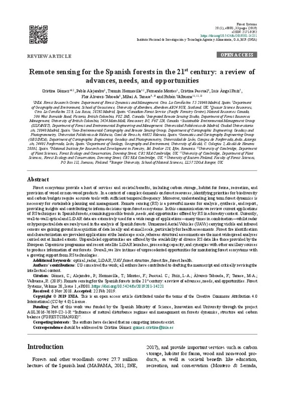 Gómez, Cristina; Alejandro, Pablo; Hermosilla, Txomin; Montes, Fernando; Pascual, Cristina; Ruiz Fernández, Luis Ángel; Álvarez-Taboada, Flor; Tanase, Mihai A.; Valbuena, Rubén (Instituto Nacional de Investigacion y Tecnologia Agraria y Alimentaria, 2019)[EN] Forest ecosystems provide a host of services and societal benefits, including carbon storage, habitat for fauna, recreation, and provision of wood or non-wood products. In a context of complex demands on forest ...
 -
 Llorca Gozálvez, Rafael (Universitat Politècnica de València, 2015-09-14)[ES] El objetivo de este trabajo es presentar una metodología sencilla y ágil para el procesado de datos LiDAR de diferentes densidades en espacios forestales y cultivados. Se utilizará software libre específico para ...
 -
 Muñoz, P.; Pastor Abellán, Daniel; Bru-Orgiles, Luis Alberto; Mico-Cabanes, Gloria; Benítez-González, Jesús; Goodwill, Dominic; Bernier, Eric (Institute of Electrical and Electronics Engineers, 2022-09)[EN] A two-dimensional optical-phased array is demonstrated by using a multiple-input star coupler, compatible with FMCW LiDAR. Previous approach using a single-input design achieves two-dimensional beam-steering by relying ...
 -
 Pena-Regueiro, Jesus; Sebastiá-Frasquet, M.-T.; Aguilar-Maldonado, Jesús Antonio; Estornell Cremades, Javier; Sanchís Blay, José Andrés; Morell-Monzó, Sergio; Altur Grau, Vicent Jesús (WIT Press, 2020)[EN] La Safor wetland is a representative coastal wetland in the Valencia Region (eastern Spain, Mediterranean Sea). This wetland is recognized at an international level as a Special Protection Area (SPAs) for birds and a ...
 -
 Hermosilla, T.; Palomar-Vázquez, Jesús; Balaguer Beser, Ángel Antonio; Balsa Barreiro, José; Ruiz Fernández, Luis Ángel (Elsevier, 2014-03)[EN] Urban spatial structures reflect local particularities produced during the development of a city. High spatial resolution imagery and LiDAR data are currently used to derive numerical attributes to describe in detail ...
 -
 Rey, Beatriz; Aleixos Borrás, María Nuria; Cubero-García, Sergio; Blasco Ivars, Jose (MDPI AG, 2019)[EN] The use of remote sensing to map the distribution of plant diseases has evolved considerably over the last three decades and can be performed at different scales, depending on the area to be monitored, as well as the ...
Mostrando ítems 61-73 de 73

Universitat Politècnica de València. Unidad de Documentación Científica de la Biblioteca (+34) 96 387 70 85 · RiuNet@bib.upv.es
El contenido de este sitio está bajo una licencia Creative Commons Reconocimiento – No Comercial – Sin Obra Derivada (by-nc-nd), salvo que se indique lo contrario.
Los metadatos de este sitio están bajo una licencia Dominio Público.
