JavaScript is disabled for your browser. Some features of this site may not work without it.
Buscar en RiuNet
Listar
Mi cuenta
Estadísticas
Ayuda RiuNet
Admin. UPV
Modelización 3D de un refugio de la guerra civil española en Ribarroja (Valencia)
Mostrar el registro sencillo del ítem
Ficheros en el ítem
| dc.contributor.advisor | Priego de los Santos, Jose Enrique
|
es_ES |
| dc.contributor.author | Soria Blat, Alejandro
|
es_ES |
| dc.coverage.spatial | east=-0.5713001; north=39.5455654; name=Carrer els Angels, 2, 46190 Riba-roja de Túria, Valencia, Espanya | es_ES |
| dc.date.accessioned | 2020-07-30T07:41:21Z | |
| dc.date.available | 2020-07-30T07:41:21Z | |
| dc.date.created | 2020-07-15 | |
| dc.date.issued | 2020-07-30 | es_ES |
| dc.identifier.uri | http://hdl.handle.net/10251/148940 | |
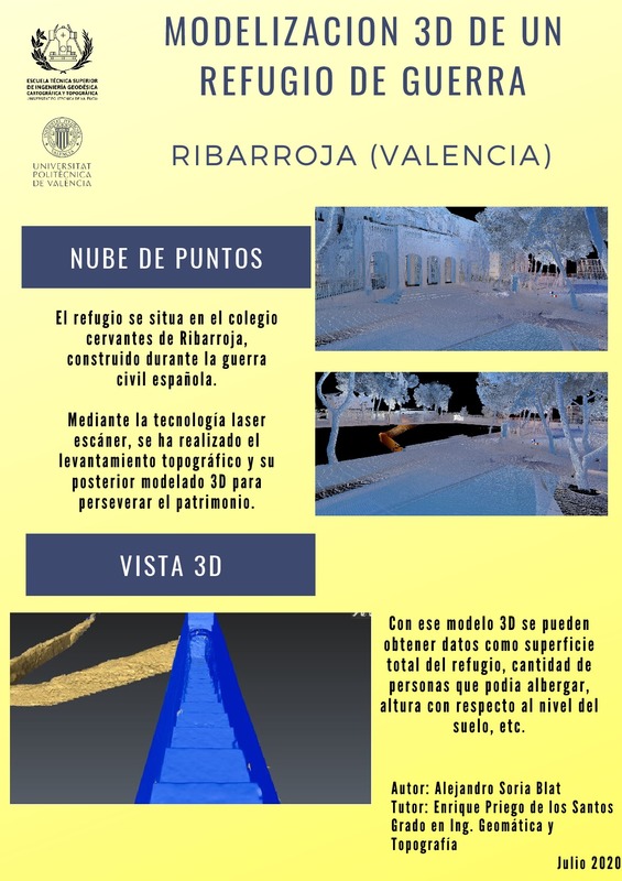
| dc.description.abstract | [ES] El objetivo de este TFG es la aplicación de la tecnología láser escáner para obtener con alta definición espacial la localización subterránea de un refugio de guerra. Una vez obtenida la nube de puntos de todo el entorno en el que se haya ubicado (debajo de un colegio), se realizaran los planos topográficos de detalles de la planta y alzado del mismo y su entorno, así como se determinaran sus dimensiones, se calculará la volumetria del mismo para hacerlo visitable en grupos reducidos, y se realizara un programa informático para la realización de una visita virtual con técnicas 3D. | es_ES |
| dc.description.abstract | [EN] The objective of this TFG is the application of laser scanning technology to obtain the underground location of a war refuge with high spatial definition. Once the cloud of points of the whole environment in which it has been located (under a school) is obtained, the topographic plans of details of the plant and elevation of the same and its environment will be made, as well as its dimensions will be determined, It will calculate the volume of the same to make it accessible in small groups, and a computer program will be carried out for the realization of a virtual visit with 3D techniques. | es_ES |
| dc.format.extent | 64 | es_ES |
| dc.language | Español | es_ES |
| dc.publisher | Universitat Politècnica de València | es_ES |
| dc.rights | Reserva de todos los derechos | es_ES |
| dc.subject | Nube de puntos | es_ES |
| dc.subject | Ribarroja del Turia (Valencia) | es_ES |
| dc.subject | Refugio de guerra | es_ES |
| dc.subject | 3D | es_ES |
| dc.subject | Láser escáner | es_ES |
| dc.subject | Refugio | es_ES |
| dc.subject | Laser scanner | es_ES |
| dc.subject | Refuge | es_ES |
| dc.subject.classification | INGENIERIA CARTOGRAFICA, GEODESIA Y FOTOGRAMETRIA | es_ES |
| dc.subject.other | Grado en Ingeniería en Geomática y Topografía-Grau en Enginyeria Geomàtica i Topografia | es_ES |
| dc.title | Modelización 3D de un refugio de la guerra civil española en Ribarroja (Valencia) | es_ES |
| dc.type | Proyecto/Trabajo fin de carrera/grado | es_ES |
| dc.rights.accessRights | Abierto | es_ES |
| dc.contributor.affiliation | Universitat Politècnica de València. Departamento de Ingeniería Cartográfica Geodesia y Fotogrametría - Departament d'Enginyeria Cartogràfica, Geodèsia i Fotogrametria | es_ES |
| dc.contributor.affiliation | Universitat Politècnica de València. Escuela Técnica Superior de Ingeniería Geodésica, Cartográfica y Topográfica - Escola Tècnica Superior d'Enginyeria Geodèsica, Cartogràfica i Topogràfica | es_ES |
| dc.description.bibliographicCitation | Soria Blat, A. (2020). Modelización 3D de un refugio de la guerra civil española en Ribarroja (Valencia). Universitat Politècnica de València. http://hdl.handle.net/10251/148940 | es_ES |
| dc.description.accrualMethod | TFGM | es_ES |
| dc.relation.pasarela | TFGM\119556 | es_ES |
Este ítem aparece en la(s) siguiente(s) colección(ones)
-
ETSIGCT - Trabajos académicos [494]
Escuela Técnica Superior de Ingeniería Geodésica, Cartográfica y Topográfica


