


Cooperación internacional al desarrollo para la gestión patrimonial. Documentación y divulgación del Patrimonio Cultural de Cantón Nabón (Ecuador)
RiuNet: Repositorio Institucional de la Universidad Politécnica de Valencia
JavaScript is disabled for your browser. Some features of this site may not work without it.
Buscar en RiuNet
Listar
Mi cuenta
Estadísticas
Ayuda RiuNet
Admin. UPV

Cooperación internacional al desarrollo para la gestión patrimonial. Documentación y divulgación del Patrimonio Cultural de Cantón Nabón (Ecuador)
Mostrar el registro sencillo del ítem
Ficheros en el ítem
| dc.contributor.advisor | Mora Navarro, Joaquín Gaspar
|
es_ES |
| dc.contributor.advisor | Lerma García, José Luis
|
es_ES |
| dc.contributor.author | Collado Murillo, Ángel
|
es_ES |
| dc.coverage.spatial | east=-79.0630932; north=-3.3365341; name=La Ramada-Nabon, Nabon, Equador | es_ES |
| dc.date.accessioned | 2021-10-04T15:01:00Z | |
| dc.date.available | 2021-10-04T15:01:00Z | |
| dc.date.created | 2021-09-17 | |
| dc.date.issued | 2021-10-04 | es_ES |
| dc.identifier.uri | http://hdl.handle.net/10251/173736 | |
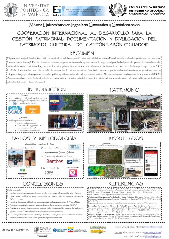
| dc.description.abstract | [ES] El presente trabajo de fin de máster está enmarcado dentro de la cooperación al desarrollo en Ecuador con la finalidad de gestionar el patrimonio de Cantón Nabón (Azuay). Dicha gestión está en la línea con el objetivo 11.4 de los 17 Objetivos de Desarrollo Sostenible (ODS) de la ONU, es decir, redoblar los esfuerzos para proteger y salvaguardar el patrimonio cultural y natural del mundo. Dicha cooperación se realizará entre la Universitat Politècnica de València (UPV) en España, la Universidad del Azuay (UDA) en Cuenca, Ecuador; el Instituto Nacional de Patrimonio Cultural de Ecuador (INPC) y el Gobierno Autónomo Descentralizado (GAD) del Cantón Nabón. Es por ello, que el presente proyecto se basa en la implementación de un geportal para la divulgación del patrimonio cultural de dicho pueblo de la sierra ecuatoriana. La gestión de los datos patrimoniales se va a llevar a cabo con la plataforma Arches que lleva incorporado el modelo de datos CIDOC-CRM, modelo que sigue la norma ISO 21127:2014, el estándar para el intercambio de información de patrimonio cultural. Para la documentación patrimonial se utilizarán técnicas geomáticas como la fotogrametría, ya sea terrestre o aérea con dron, que permitirán generar productos gráficos y métricos del citado patrimonio como modelos 3D que podrán ser visualizados en línea gracias a 3DHOP. Asimismo, Arches dispone de la app móvil Arches Collector que permitirá realizar el inventariado in situ de los elementos patrimoniales y también la monitorización a lo largo del tiempo de los bienes culturales. Los productos generados, así como el inventario patrimonial creado serán puestos a disposición de la sociedad a través de internet mediante un geoportal web (https://patrimoniocantonnabon.tk/es/) alojado en un servidor web dependiente del Departamento de Ingeniería Cartográfica, Geodesia y Fotogrametría de la UPV, aunque se aspira a que el propio municipio de Cantón Nabón sea capaz de gestionar y funcionar autónomamente con sus propios recursos humanos y materiales en un plazo cercano | es_ES |
| dc.description.abstract | [EN] This master's thesis is framed within development cooperation in Ecuador with the aim of managing the heritage of Canton Nabón (Azuay). This management is in line with the objective 11.4 of the 17 Sustainable Development Goals (SDG) of the UN, i.e. to redouble efforts to protect and safeguard the cultural and natural heritage of the world. This cooperation will be carried out between the Universitat Politècnica de València (UPV) in Spain, the Universidad del Azuay (UDA) in Cuenca, Ecuador; the National Institute of Cultural Heritage of Ecuador (INPC) and the Decentralized Autonomous Government (GAD) of Cantón Nabón. Therefore, this project is based on the implementation of a geoportal for the dissemination of the cultural heritage of this town in the Ecuadorian highlands. The management of heritage data will be carried out with the Arches platform that incorporates the CIDOC-CRM data model, a model that follows ISO 21127:2014, the standard for the exchange of cultural heritage information. For heritage documentation, geomatics techniques such as photogrammetry will be used, either terrestrial or aerial with drone, which will allow the generation of graphic and metric products of the aforementioned heritage as 3D models that will be able to view online thanks to 3DHOP. In addition, Arches has the mobile app Arches Collector that will allow the on site inventory of the heritage elements and also the monitoring of the cultural assets over time. The products generated, as well as the heritage inventory created will be made available to society through the Internet with a web geoportal (https://patrimoniocantonnabon.tk/es/) hosted on a web server dependent of the Department of Cartographic Engineering, Geodesy and Photogrammetry of the UPV, although it is hoped that the municipality of Canton Nabón will be able to manage itself and operate autonomously with its own human and material resources in the near future. | es_ES |
| dc.format.extent | 263 | es_ES |
| dc.language | Español | es_ES |
| dc.publisher | Universitat Politècnica de València | es_ES |
| dc.rights | Reserva de todos los derechos | es_ES |
| dc.subject | Objetivos de Desarrollo Sostenible (ODS) | es_ES |
| dc.subject | Cooperación | es_ES |
| dc.subject | Ecuador | es_ES |
| dc.subject | Cantón Nabón | es_ES |
| dc.subject | Geoportal | es_ES |
| dc.subject | Geomática | es_ES |
| dc.subject | Patrimonio | es_ES |
| dc.subject | Modelización 3D | es_ES |
| dc.subject | Geovisualización | es_ES |
| dc.subject | Arches | es_ES |
| dc.subject | Cooperation | es_ES |
| dc.subject | Sustainable Development Goals (SDGs) | es_ES |
| dc.subject | Geomatics | es_ES |
| dc.subject | Heritage | es_ES |
| dc.subject | 3D modeling | es_ES |
| dc.subject | Geovisualisation | es_ES |
| dc.subject.classification | INGENIERIA CARTOGRAFICA, GEODESIA Y FOTOGRAMETRIA | es_ES |
| dc.subject.other | Máster Universitario en Ingeniería Geomática y Geoinformación-Màster Universitari en Enginyeria Geomàtica i Geoinformació | es_ES |
| dc.title | Cooperación internacional al desarrollo para la gestión patrimonial. Documentación y divulgación del Patrimonio Cultural de Cantón Nabón (Ecuador) | es_ES |
| dc.type | Tesis de máster | es_ES |
| dc.relation.projectID | info:eu-repo/grantAgreement/UPV//AD1906/ | es_ES |
| dc.rights.accessRights | Abierto | es_ES |
| dc.contributor.affiliation | Universitat Politècnica de València. Departamento de Ingeniería Cartográfica Geodesia y Fotogrametría - Departament d'Enginyeria Cartogràfica, Geodèsia i Fotogrametria | es_ES |
| dc.contributor.affiliation | Universitat Politècnica de València. Escuela Técnica Superior de Ingeniería Geodésica, Cartográfica y Topográfica - Escola Tècnica Superior d'Enginyeria Geodèsica, Cartogràfica i Topogràfica | es_ES |
| dc.description.bibliographicCitation | Collado Murillo, Á. (2021). Cooperación internacional al desarrollo para la gestión patrimonial. Documentación y divulgación del Patrimonio Cultural de Cantón Nabón (Ecuador). Universitat Politècnica de València. http://hdl.handle.net/10251/173736 | es_ES |
| dc.description.accrualMethod | TFGM | es_ES |
| dc.relation.pasarela | TFGM\141931 | es_ES |
| dc.contributor.funder | Universitat Politècnica de València | es_ES |
| dc.contributor.funder | UNIVERSIDAD POLITECNICA DE VALENCIA | es_ES |
Este ítem aparece en la(s) siguiente(s) colección(ones)
-
ETSIGCT - Trabajos académicos [494]
Escuela Técnica Superior de Ingeniería Geodésica, Cartográfica y Topográfica

Universitat Politècnica de València. Unidad de Documentación Científica de la Biblioteca (+34) 96 387 70 85 · RiuNet@bib.upv.es
El contenido de este sitio está bajo una licencia Creative Commons Reconocimiento – No Comercial – Sin Obra Derivada (by-nc-nd), salvo que se indique lo contrario.
Los metadatos de este sitio están bajo una licencia Dominio Público.
