JavaScript is disabled for your browser. Some features of this site may not work without it.
Buscar en RiuNet
Listar
Mi cuenta
Estadísticas
Ayuda RiuNet
Admin. UPV
Estimación de la biomasa forestal del Pirineo Central mediante teledetección y SIG
Mostrar el registro sencillo del ítem
Ficheros en el ítem
| dc.contributor.advisor | Coll Aliaga, Peregrina Eloína
|
es_ES |
| dc.contributor.advisor | Vinué Visús, David
|
es_ES |
| dc.contributor.author | Urrecho Torres, Javier
|
es_ES |
| dc.coverage.spatial | east=-0.6773045999999999; north=42.6273497; name=22740, Huesca, Espanya | es_ES |
| dc.date.accessioned | 2021-10-06T10:50:43Z | |
| dc.date.available | 2021-10-06T10:50:43Z | |
| dc.date.created | 2021-09-21 | |
| dc.date.issued | 2021-10-06 | es_ES |
| dc.identifier.uri | http://hdl.handle.net/10251/173983 | |
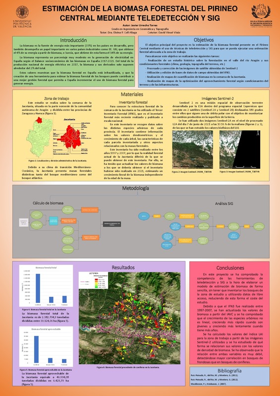
| dc.description.abstract | [ES] El primer paso para una adecuada ordenación forestal es la cuantificación de las existencias de biomasa. Esto se realiza típicamente mediante inventarios forestales en general largos y costosos, si bien existen alternativas para la estimación de los recursos forestales de forma rápida, sencilla y eficaz mediante métodos avanzados basados en la teledetección por satélite y apoyados por herramientas SIG. En este TFG se estimará la biomasa en una zona del Pirineo Central mediante técnicas de teledetección y SIG para lo cual: a) se realizará un estudio histórico sobre la forestación en el Valle del Aragón y los condicionantes forestales; b) se procesarán las imágenes de satélite adecuadas; c) se utilizarán datos LiDAR para ayudar en la toma de decisiones; d) se usarán bases de datos de campo, obtenidas del IFN; e) se realizarán mapas de la biomasa en el Valle y se determinarán las zonas de explotación y la distancia a la central; f) se obtendrán mapas de la optimización del aprovechamiento según las condiciones de pendiente y distancias a las pistas de desembosque. | es_ES |
| dc.description.abstract | [EN] The first step for proper forest management is the quantification of biomass stocks. This is typically done through long and costly forest inventories, although there are alternatives for estimating forest resources quickly, easily and efficiently using advanced methods based on satellite remote sensing and supported by GIS tools. In this TFG the biomass in an area of ​​the Central Pyrenees will be estimated using remote sensing and GIS techniques, for which: a) a historical study will be carried out on afforestation in the Aragon Valley and the forest conditions; b) appropriate satellite images will be processed; c) LiDAR data will be used to aid decision making; d) field databases will be used, obtained from IFN; e) biomass maps will be made in the Valley and the exploitation areas and distance from the plant will be determined; f) Harvest optimization maps will be obtained according to the slope conditions and distances to the landing tracks. | es_ES |
| dc.format.extent | 57 | es_ES |
| dc.language | Español | es_ES |
| dc.publisher | Universitat Politècnica de València | es_ES |
| dc.rights | Reconocimiento (by) | es_ES |
| dc.subject | Jacetania | es_ES |
| dc.subject | Sentinel-2 | es_ES |
| dc.subject | Aragón | es_ES |
| dc.subject | SIG | es_ES |
| dc.subject | Biomasa | es_ES |
| dc.subject | LiDAR | es_ES |
| dc.subject | Pirineo Central | es_ES |
| dc.subject | Inventario forestal | es_ES |
| dc.subject | Teledetección | es_ES |
| dc.subject | GIS | es_ES |
| dc.subject | Biomass | es_ES |
| dc.subject | Forest inventory | es_ES |
| dc.subject | Remote sensing | es_ES |
| dc.subject.classification | INGENIERIA CARTOGRAFICA, GEODESIA Y FOTOGRAMETRIA | es_ES |
| dc.subject.other | Grado en Ingeniería en Geomática y Topografía-Grau en Enginyeria Geomàtica i Topografia | es_ES |
| dc.title | Estimación de la biomasa forestal del Pirineo Central mediante teledetección y SIG | es_ES |
| dc.type | Proyecto/Trabajo fin de carrera/grado | es_ES |
| dc.rights.accessRights | Abierto | es_ES |
| dc.contributor.affiliation | Universitat Politècnica de València. Departamento de Ingeniería Cartográfica Geodesia y Fotogrametría - Departament d'Enginyeria Cartogràfica, Geodèsia i Fotogrametria | es_ES |
| dc.contributor.affiliation | Universitat Politècnica de València. Escuela Técnica Superior de Ingeniería Geodésica, Cartográfica y Topográfica - Escola Tècnica Superior d'Enginyeria Geodèsica, Cartogràfica i Topogràfica | es_ES |
| dc.description.bibliographicCitation | Urrecho Torres, J. (2021). Estimación de la biomasa forestal del Pirineo Central mediante teledetección y SIG. Universitat Politècnica de València. http://hdl.handle.net/10251/173983 | es_ES |
| dc.description.accrualMethod | TFGM | es_ES |
| dc.relation.pasarela | TFGM\145719 | es_ES |
Este ítem aparece en la(s) siguiente(s) colección(ones)
-
ETSIGCT - Trabajos académicos [494]
Escuela Técnica Superior de Ingeniería Geodésica, Cartográfica y Topográfica


