


LA DESEMBOCADURA DEL TURIA. INFRAESTRUCTURA HIDRÁULICA Y TERRITORIO
RiuNet: Repositorio Institucional de la Universidad Politécnica de Valencia
- RiuNet repositorio UPV
- :
- Investigación
- :
- Tesis doctorales
- :
- Ver ítem
JavaScript is disabled for your browser. Some features of this site may not work without it.
Buscar en RiuNet
Listar
Mi cuenta
Estadísticas
Ayuda RiuNet
Admin. UPV


LA DESEMBOCADURA DEL TURIA. INFRAESTRUCTURA HIDRÁULICA Y TERRITORIO
Mostrar el registro sencillo del ítem
Ficheros en el ítem
| dc.contributor.advisor | Alonso-De-Armiño Pérez, Luís
|
es_ES |
| dc.contributor.author | García Sogo, María Lourdes
|
es_ES |
| dc.date.accessioned | 2017-11-06T13:05:37Z | |
| dc.date.available | 2017-11-06T13:05:37Z | |
| dc.date.created | 2017-09-26 | es_ES |
| dc.date.issued | 2017-11-06 | es_ES |
| dc.identifier.uri | http://hdl.handle.net/10251/90568 | |
| dc.description.abstract | The Turia river-mouth is a territorial unit whose boundaries are defined by the river's flowing irrigation ditches, the shores of the lagoon sited between both Turia and Júcar river-mouths, and the waters of the Mediterranean Sea. Man has gradually and profoundly transformed this territory. The transformation began sometime after the 2nd century BC, and has never ceased. The guideline to understand this transformation is to follow the development of the hydraulic infrastructures that have been endlessly changing the river, the lagoon and the coastline. Man-made changes to the river were aimed at irrigation, water supply and defence against its recurrent torrential swells. Environmental alterations in the lagoon were aimed at food production, whereas those at the seafront were aimed at facilitating trade. The construction of the city of Valencia and other minor settlements went on simultaneously, growing and acquiring its own form while interspersing or overlapping with these infrastructures. An orderly analysis of the events giving rise to the construction of the various different infrastructures will allow us a better insight into the origin and the structure of this territory. We have divided the analysis into two major periods. The first one extends for almost two thousand years, from 138 a.C., date on which the city of Valencia is founded, until about 1700. When this period ended, the many built-up infrastructures had not been able to completely fulfill its objectives. The river waters already irrigated a perfect orchard, but periods of famine endangered the crops. Seasonal river swells periodically flooded the city. Supposedly fresh drinking waters were frequently unhealthy, the lagoon drainage was not efficiently controlled, and on the coast, despite many attempts, port facilities had not gone beyond building a modest wooden pier. The second period begins about 1700, when first steps were taken towards industrial production and consequently, towards achieving a new and powerful capacity for transforming the territory. This period ends in 1973, the year in which the works for the new artificial riverbed channel were concluded. The infrastructures built in this period fulfilled their objectives. Healthy river water-supply arrived to the city network with sufficient flow and pressure. The orchard lands were irrigated without suffering periods of famine. Turia river seasonal swells did not flood the city again, and city sanitation was renewed. In the transformed Albufera, irrigation and drainage systems were controlled and rice harvests from the new earth-filled plots were regularly collected. The port was thoroughly built and continued to expand, and Valencia finally had adequate facilities for its maritime trade. Without the fulfillment of these objectives, the making of the industrial city would not have been possible, but the development of these infrastructures and the way in which the city grew have given place, with time, to a fragmented, hardly meaningful territory. This analysis allows us to reach the origins of the transformation and to understand the true structure of this territory. And to find out that, behind man-made mistakes that may obscure its profile, there remains a powerful reality, which once recognized, will not be difficult to pursue. | en_EN |
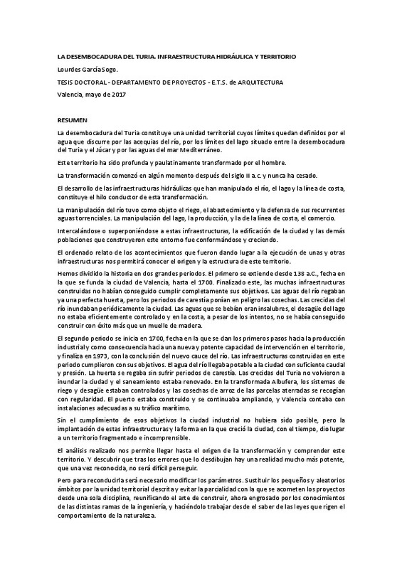
| dc.description.abstract | La desembocadura del Turia constituye una unidad territorial cuyos límites quedan definidos por el agua que discurre por las acequias del río, por los límites del lago situado entre la desembocadura del Turia y el Júcar y por las aguas del mar Mediterráneo. Este territorio ha sido profunda y paulatinamente transformado por el hombre. La transformación comenzó en algún momento despues del siglo II a.c. y nunca ha cesado. El desarrollo de las infraestructuras hidráulicas que han manipulado el río, el lago y la línea de costa, constituye el hilo conductor de esta transformación. La manipulación del río tuvo como objeto el riego, el abastecimiento y la defensa de sus recurrentes aguas torrenciales. La manipulación del lago, la producción, y la de la línea de costa, el comercio. Intercalándose o superponiéndose a estas infraestructuras, la edificación de la ciudad y las demás poblaciones que construyeron este entorno fue conformándose y creciendo. El ordenado relato de los acontecimientos que fueron dando lugar a la ejecución de unas y otras infraestructuras nos permitirá conocer el origen y la estructura de este territorio. Hemos dividido el análisis en dos grandes periodos. El primero se extiende desde 138 a.C., fecha en la que se funda la ciudad de Valencia, hasta el 1700. Finalizado este, las muchas infraestructuras construidas no habían conseguido cumplir completamente sus objetivos. Las aguas del río regaban ya una perfecta huerta, pero los periodos de carestía ponían en peligro las cosechas. Las crecidas del río inundaban periódicamente la ciudad. Las aguas que se bebían eran insalubres, el desagüe del lago no estaba eficientemente controlado y en la costa, a pesar de los intentos, no se había conseguido construir con éxito más que un muelle de madera. El segundo periodo se inicia en 1700, fecha en la que se dan los primeros pasos hacia la producción industrial y como consecuencia hacia una nueva y potente capacidad de intervención en el territorio. Y finaliza en 1973, fecha en que se concluye el nuevo cauce del río. Las infraestructuras construidas en este periodo cumplieron con sus objetivos. El agua del río llegaba potable a la ciudad con suficiente caudal y presión. La huerta se regaba sin sufrir periodos de carestía. Las crecidas del Turia no volvieron a inundar la ciudad y el saneamiento estaba renovado. En la transformada Albufera, los sistemas de riego y desagüe estaban controlados y las cosechas de arroz de las parcelas aterradas se recogían con regularidad. El puerto estaba construido y se continuaba ampliando, y Valencia contaba con instalaciones adecuadas a su tráfico marítimo. Sin el cumplimiento de esos objetivos la ciudad industrial no hubiera sido posible, pero la implantación de estas infraestructuras y la forma en la que creció la ciudad, con el tiempo, dio lugar a un territorio fragmentado e incomprensible. El análisis realizado nos permite llegar hasta el origen de la transformación y comprender la verdadera estructura de este territorio. Y descubrir que tras los errores que lo desdibujan hay una realidad mucho más potente, que una vez reconocida, no será difícil perseguir. | es_ES |
| dc.description.abstract | La desembocadura del Turia constitueix una unitat territorial els límits de la qual queden definits per l'aigua que discorre per les sèquies del riu, pels límits del llac situat entre la desembocadura del Turia i el Xúquer i per les aigües del mar Mediterrani. Aquest territori ha sigut profunda i gradualment transformat per l'home. La transformació va començar en algun moment després del segle II a.c. i mai ha cessat. El desenvolupament de les infraestructures hidràuliques que han manipulat el riu, el llac i la línia de costa, constitueix el fil conductor d'aquesta transformació. La manipulació del riu va tenir com a objecte el reg, el proveïment i la defensa de les seues recurrents aigües torrencials. La manipulació del llac, la producció, i la de la línia de costa, el comerç. Intercalant-se o superposant-se a aquestes infraestructures, l'edificació de la ciutat i les altres poblacions que van construir aquest entorn va ser conformant-se i creixent. L'ordenat relat dels esdeveniments que van anar donant lloc a l'execució d'unes i unes altres infraestructures ens permetrà conèixer l'origen i l'estructura d'aquest territori. Hem dividit l'anàlisi en dos grans períodes. El primer s'estén des de 138 a.c., data en la qual es funda la ciutat de València, fins al 1700. Finalitzat aquest, les moltes infraestructures construïdes no havien aconseguit complir completament els seus objectius. Les aigües del riu regaven ja una perfecta horta, però els períodes de carestia posaven en perill les collites. Les crescudes del riu inundaven periòdicament la ciutat. Les aigües que es bevien eren insalubres, el desguàs del llac no estava eficientment controlat i en la costa, malgrat els intents, no s'havia aconseguit construir amb èxit més que un moll de fusta. El segon període s'inicia en 1700, data en la qual es donen els primers passos cap a la producció industrial i com a conseqüència cap a una nova i potent capacitat d'intervenció en el territori. I finalitza en 1973, data en què es conclou el nou llit del riu. Les infraestructures construïdes en aquest període van complir amb els seus objectius. L'aigua del riu arribava potable a la ciutat amb suficient cabal i pressió. L'horta es regava sense patir períodes de carestia. Les crescudes del Turia no van tornar a inundar la ciutat i el sanejament estava renovat. En la transformada Albufera, els sistemes de reg i desguàs estaven controlats i les collites d'arròs de les parcel.les aterrides s'arreplegaven amb regularitat. El port estava construït i es continuava ampliant, i València comptava amb instal.lacions adequades al seu tràfic marítim. Sense el compliment d'aqueixos objectius la ciutat industrial no haguera sigut possible, però la implantació d'aquestes infraestructures i la forma en la qual va créixer la ciutat, amb el temps, va donar lloc a un territori fragmentat i incomprensible. L'anàlisi realitzada ens permet arribar fins a l'origen de la transformació i comprendre la vertadera estructura d'aquest territori. I descobrir que després dels errors que ho desdibuixen hi ha una realitat molt més potent, que una vegada reconeguda, no serà difícil perseguir. | ca_ES |
| dc.language | Español | es_ES |
| dc.publisher | Universitat Politècnica de València | es_ES |
| dc.rights | Reserva de todos los derechos | es_ES |
| dc.subject | Valencia | es_ES |
| dc.subject | desembocadura | es_ES |
| dc.subject | Turia | es_ES |
| dc.subject | Júcar | es_ES |
| dc.subject | Albufera | es_ES |
| dc.subject | acequias | es_ES |
| dc.subject | riego | es_ES |
| dc.subject | huerta | es_ES |
| dc.subject | agua potable | es_ES |
| dc.subject | abastecimiento | es_ES |
| dc.subject | saneamiento | es_ES |
| dc.subject | pretil | es_ES |
| dc.subject | puerto | es_ES |
| dc.subject | territorio | es_ES |
| dc.subject | infraestructura hidráulica | es_ES |
| dc.subject | canal | es_ES |
| dc.subject | nuevo cauce | es_ES |
| dc.subject | ciudad industrial | es_ES |
| dc.subject.classification | URBANISTICA Y ORDENACION DEL TERRITORIO | es_ES |
| dc.title | LA DESEMBOCADURA DEL TURIA. INFRAESTRUCTURA HIDRÁULICA Y TERRITORIO | es_ES |
| dc.type | Tesis doctoral | es_ES |
| dc.identifier.doi | 10.4995/Thesis/10251/90568 | es_ES |
| dc.rights.accessRights | Abierto | es_ES |
| dc.contributor.affiliation | Universitat Politècnica de València. Departamento de Proyectos Arquitectónicos - Departament de Projectes Arquitectònics | es_ES |
| dc.description.bibliographicCitation | García Sogo, ML. (2017). LA DESEMBOCADURA DEL TURIA. INFRAESTRUCTURA HIDRÁULICA Y TERRITORIO [Tesis doctoral no publicada]. Universitat Politècnica de València. https://doi.org/10.4995/Thesis/10251/90568 | es_ES |
| dc.description.accrualMethod | TESIS | es_ES |
| dc.type.version | info:eu-repo/semantics/acceptedVersion | es_ES |
| dc.relation.pasarela | TESIS\9655 | es_ES |
Este ítem aparece en la(s) siguiente(s) colección(ones)
-
Tesis doctorales [5300]

Universitat Politècnica de València. Unidad de Documentación Científica de la Biblioteca (+34) 96 387 70 85 · RiuNet@bib.upv.es
El contenido de este sitio está bajo una licencia Creative Commons Reconocimiento – No Comercial – Sin Obra Derivada (by-nc-nd), salvo que se indique lo contrario.
Los metadatos de este sitio están bajo una licencia Dominio Público.
