


Listar por autor "Estornell Cremades, Javier"
RiuNet: Repositorio Institucional de la Universidad Politécnica de Valencia
- RiuNet repositorio UPV
- :
- Listar por autor
JavaScript is disabled for your browser. Some features of this site may not work without it.
Buscar en RiuNet
Listar
Mi cuenta
Ayuda RiuNet
Admin. UPV
Listar por autor "Estornell Cremades, Javier"
Mostrando ítems 1-20 de 77
-
 Carbonell-Rivera, Juan Pedro; Estornell, Javier; Ruiz, Luis; Abad, Alfonso; Felten, Bettina; Torralba, Jesús (Editorial Universitat Politècnica de València, 2021-10-01)[EN] In recent years, Remote Sensing (RS) and its derived products have been used as a key tool for the detection, monitoring, management and future use of Marginal Lands (ML). Currently, there is no single, universally ...
 -
 Hadás, Edyta; Estornell Cremades, Javier (Taylor & Francis, 2016)[EN] The aim of this study was to compare geometric parameters of olive trees (tree height, crown base height, crown diameters, crown area), using LiDAR data of different densities: 0.5, 3.5 and 9 points m(-2). Two strategies ...
 -
 Sebastiá-Frasquet, M.-T.; Aguilar-Maldonado, Jesús Antonio; Herrero-Durá, Iván; Santamaría-del-Ángel, Eduardo; Morell-Monzó, Sergio; Estornell Cremades, Javier (MDPI AG, 2020-11)[EN] Since remote sensing of ocean colour began in 1978, several ocean-colour sensors have been launched to measure ocean properties. These measures have been applied to study water quality, and they specifically can be ...
 -
 Gracia Calandin, Carlos Pablo; Velázquez Martí, Borja; Estornell Cremades, Javier (Elsevier, 2014-08)[EN] Pruning is a cultural operation linked to Mediterranean agricultural management and it offers through its wastes the chance to procure biofuels. Currently, these residues are disposed of by burning or shredding, not ...
 -
Martínez Martí, Noel (Universitat Politècnica de València, 2013-07-29)Forest fires are a real problem at the interface of vegetation and settlements with several areas being burnt annually along the Mediterranean coast. This thesis is focused on the La Ribera Alta (RA) region where a Spanish ...
-
 Estornell Cremades, Javier; Ruiz Fernández, Luis Ángel; Velázquez Martí, Borja; Hermosilla, T. (Taylor & Francis: STM, Behavioural Science and Public Health Titles, 2011)[EN] The creation of a quality Digital Terrain Model (DTM) is essential for representing and analyzing the Earth in a digital form. The continuous improvements in the acquisition and the potential of airborne Light Detection ...
 -
 Crespo-Peremarch, Pablo; Ruiz Fernández, Luis Ángel; Balaguer-Beser, Ángel; Estornell Cremades, Javier (Elsevier, 2018)[EN] LiDAR full-waveform (LFW) pulse density is not homogeneous along study areas due to overlap between contiguous flight stripes and, to a lesser extent, variations in height, velocity and altitude of the platform. As a ...
 -
 Estruch Benito, Francisco (Universitat Politècnica de València, 2011-01-18)
 -
 Escrivà Peiró, Antoni (Universitat Politècnica de València, 2017-10-05)In this work it is proposed an alternative system to the traditional methods of field work for the analysis of riparian vegetation afected by the regulation of channels in rough terrain or with hard access. The main goal ...
 -
 Estornell Cremades, Javier (Universitat Politècnica de València, 2011-09-12)Los objetivos de esta investigación han sido adaptar un algoritmo basado en procesos iterativos de búsqueda de elevaciones mínimas a partir de datos LiDAR para el cálculo de un MDE en zonas de montaña mediterránea, y ...
 -
Puig Mengual, Carlos Antonio (Universitat Politècnica de València, 2014-12-04)En este treball es va plantejar i desenrotllar una metodologia per a la delineació i extracció de forma individual de les diferents copes arbòries que es troben situades en l’àmbit de la zona d’estudi per mitjà de dades ...
-
 Pellicer, I.; Estornell Cremades, Javier; Martí, J. (Editorial Universitat Politècnica de València, 2014-06-24)[EN] The environmental impact assessment and landscape analysis of any work or activity over the territory requires a study of the visual impact what can be done from the application of viewshed analysis. The accuracy of ...
 -
 Jordán Francés, Vicente (Universitat Politècnica de València, 2015-09-23)The urban cadastral renovation is a necessary practice for all municipalities, since it can lead to the detection of structural irregularities not contemplated in the land. These irregularities directly or indirectly ...
 -
 Herrero Durá, Iván (Universitat Politècnica de València, 2012-04-27)
 -
 Estornell Cremades, Javier; Marti Gavila, Jesus; Velázquez Martí, Borja; Siscar Galindo, Carlos (Universitat Politècnica de Catalunya, 2011)[ES] El rápido desarrollo urbanístico de las zonas costeras ha generado la necesidad de definir herramientas que permitan estudiar los crecimientos de las ciudades de manera rápida y precisa. La disponibilidad de ...
 -
 Romero Estrugo, Lluís (Universitat Politècnica de València, 2015-07-28)La aplicación de sistemas de información geográfica (SIG) en el ámbito de las ciencias ambientales es cada vez mayor, como así se demuestra en la elevada cantidad de estudios en hidrología, edafología, gestión forestal, ...
 -
 Hernandez Garcia, Miguel Angel (Universitat Politècnica de València, 2017-10-05)Los softwares de sistemas de información geográfica (SIG) están adquiriendo gran importancia en la realización de estudios relacionados con las ciencias ambientales dado el potencial que tienen a la hora de trabajar y ...
 -
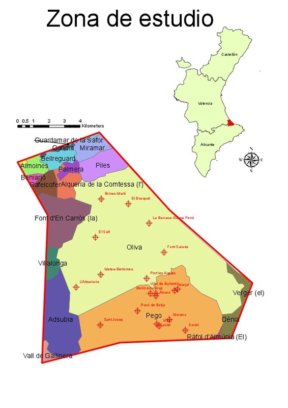
 Morell-Monzó, Sergio; Estornell Cremades, Javier; Sebastiá-Frasquet, M.-T. (Elsevier, 2023-01)[EN] Agricultural land abandonment is an increasing phenomenon around the world with relevant environmental and socio-economic implications. In the European Union about 11 % of agricultural land is at high risk of abandonment. ...
 -
 Estornell Cremades, Javier; Ruiz Fernández, Luis Ángel; Velázquez Martí, Borja; Hermosilla Gómez, Txomin (Society of Photo-optical Instrumentation Engineers (SPIE), 2012)Shrub vegetation is a key element of Mediterranean forest areas and it is necessary to develop tools that allow a precise knowledge of this vegetation. This study aims to predict shrub volume and analyze the factors affecting ...
 -
Hadas, Edyta; Borkowski, Andrzej; Estornell Cremades, Javier; Tymkow, Przemyslaw (Taylor & Francis, 2017)[EN] The aim of this study is to present an automatic approach for olive tree dendrometric parameter estimation from airborne laser scanning (ALS) data. The proposed method is based on a unique combination of the alpha-shape ...
Mostrando ítems 1-20 de 77

Universitat Politècnica de València. Unidad de Documentación Científica de la Biblioteca (+34) 96 387 70 85 · RiuNet@bib.upv.es
El contenido de este sitio está bajo una licencia Creative Commons Reconocimiento – No Comercial – Sin Obra Derivada (by-nc-nd), salvo que se indique lo contrario.
Los metadatos de este sitio están bajo una licencia Dominio Público.
