


Listar por palabra clave "Geophysics"
RiuNet: Repositorio Institucional de la Universidad Politécnica de Valencia
- RiuNet repositorio UPV
- :
- Listar por palabra clave
JavaScript is disabled for your browser. Some features of this site may not work without it.
Buscar en RiuNet
Listar
Mi cuenta
Ayuda RiuNet
Admin. UPV
Listar por palabra clave "Geophysics"
Mostrando ítems 21-40 de 42
-
 Romero Jarén, Rocío; Quirós, Ligia; Sorondo, Fernando; Benito, Belén (Editorial Universitat Politècnica de València, 2017-10-23)[EN] An estimation of the seismic risk in Castilla - La Mancha (Spain) is set forth in the current work, in order to develop the special emergency programme. To carry out the study it has been necessary to define a ...
 -
 González-Jiménez, Miguel; Guardiola-Albert, Carolina; Aguilera-Alonso, Héctor; Béjar- Pizarro, Marta; Herrera, Gerardo; Ezquerro, Pablo; López-Vinielles, Juan; Fernández, Natalia; Ruiz-Bermudo, Fernando (Editorial Universitat Politècnica de València, 2021-10-01)[EN] Groundwater is one of the most important hydric resources of the Spain territory. Nevertheless, heavy groundwater withdrawal generates severe consequences, being land subsidence one of them. The Interferometric ...
 -
 Rodrigo-Comino, Jesús; Terol, Enric; Cerdà, Artemi (Editorial Universitat Politècnica de València, 2021-10-01)[EN] Policymakers, stakeholders and rural inhabitants must be aware of the relevance of soil erosion as an irreversible landdegradation process. This is key to achieve the land degradation neutrality challenge and the ...
 -
 Land subsidence analysis caused by aquifer overexploitation using GEP tools: A-DInSAR on the cloud Bru, Guadalupe; Ezquerro, Pablo; Guardiola-Albert, Carolina; Béjar-Pizarro, Marta; Herrera, Gerardo; Tomás, Roberto; Navarro-Hernández, María; López-Sanchez, Juan; Ören, Ali; Çaylak, Barış; Elçi, Alper; Shatanawi, Khaldoun; Mohammad, Alsharifa; Abu Hajar, Husam; Bonì, Roberta; Meisina, Claudia (Editorial Universitat Politècnica de València, 2021-10-01)[EN] Groundwater is a vitally important resource for humans. One of the main problems derived from the overexploitation of aquifers is land subsidence, which in turn carries other associated natural risks. Advanced ...
 -
 Zid, Ferdous; Vigo, Isabel; García, David (Editorial Universitat Politècnica de València, 2021-10-01)[EN] In this work, we provide an updated geodetic approach to the Mediterranean Surface Geostrophic circulation based on satellite data. We follow same methodology as in a previous approach by Vigo et al. (2018), but here ...
 -
 Navarro, José; Barra, Anna; Monserrat, Oriol; Crosetto, Michele (Editorial Universitat Politècnica de València, 2021-10-01)[EN] The PSIG software chain, which has been producing terrain displacement maps for one and a half decades now, has been entirely developed by the members of the Geomatics Division of the Centre Tecnològic de Telecomunicacions ...
 -
 Sánchez, Jaime (Editorial Universitat Politècnica de València, 2021-10-01)[EN] DInSAR technology provides high density of information about the temporal ground and infrastructure deformation rate with millimetre precision and without the need of ground instrumentation. DInSAR analyses the ...
 -
 Torralba, Jesús; Ruiz, Luis; Georgiadis, Charalampos; Patias, Petros; Gómez-Conejo, Rodrigo; Verde, Natalia; Tassapoulou, Maria; Bezares Sanfelip, Fernando; Grommy, Ewa; Aleksandrowicz, Sebastian; Krätzschmar, Elke; Krupiński, Michał; Carbonell-Rivera, Juan (Editorial Universitat Politècnica de València, 2021-10-01)[EN] The concept of marginal land (ML) is dynamic and depends on various factors related to the environment, climate, scale, culture, and economic sector. The current methods for identifying ML are diverse, they employ ...
 -
 Fredes, Sandra; Ruiz Fernández, Luis Ángel; Recio Recio, Jorge Abel (Editorial Universitat Politècnica de València, 2021-10-01)[EN] In order to monitor the ripeness and composition of wine grape berries and establish an optimal harvest date, the determination of °Brix and pH is vital. This research includes the study of two wine grapes harvests ...
 -
 Vargas, Wilson; Femenia, Carmen (Editorial Universitat Politècnica de València, 2021-10-01)[EN] Bogotá, the capital of Colombia, is the first most congested city in the world after Bucharest and New York. In Bogotá there are several applications (Apps) that allow the user to plan their trip in each of the ...
 -
 Arcos, María; Balaguer-Beser, Ángel; Ruiz, Luis (Editorial Universitat Politècnica de València, 2021-10-01)[EN] The water content of the vegetation affects the flammability of the vegetation and fire behavior. A standard measure of this parameter is the live fuel moisture content (LFMC), calculated as the percentage of humidity ...
 -
 Ruiz-Armenteros, Antonio; Delgado-Blasco, José; Bakon, Matus; Lazecky, Milan; Marchamalo-Sacristán, Miguel; Lamas-Fernández, Francisco; Ruiz-Constán, Ana; Galindo-Zaldívar, Jesús; Sanz de Galdeano, Carlos; Martos-Rosillo, Sergio; Papco, Juraj; Perissin, Daniele; Sousa, Joaquim (Editorial Universitat Politècnica de València, 2021-10-01)[EN] Synthetic Aperture Radar Interferometry (InSAR) is a remote sensing technique very effective for the measure of smalldisplacements of the Earth’s surface over large areas at a very low cost as compared with conventional ...
 -
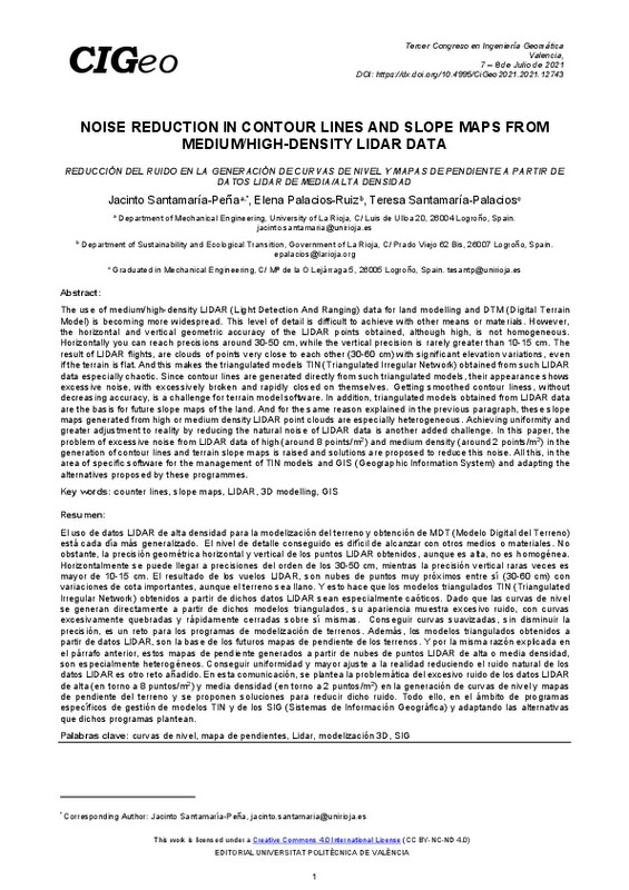 Santamaría-Peña, Jacinto; Palacios-Ruiz, Elena; Santamaría-Palacios, Teresa (Editorial Universitat Politècnica de València, 2021-10-01)[EN] The use of medium/high-density LIDAR (Light Detection And Ranging) data for land modelling and DTM (Digital Terrain Model) is becoming more widespread. This level of detail is difficult to achieve with other means ...
 -
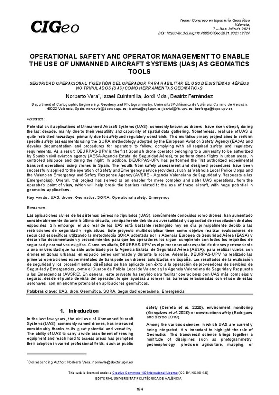 Vera, Norberto; Quintanilla, Israel; Vidal, Jordi; Fernández, Beatriz (Editorial Universitat Politècnica de València, 2021-10-01)[EN] Potential civil applications of Unmanned Aircraft Systems (UAS), commonly known as drones, have risen steeply during the last decade, mainly due to their versatility and capability of spatial data gathering. Nonetheless, ...
 -
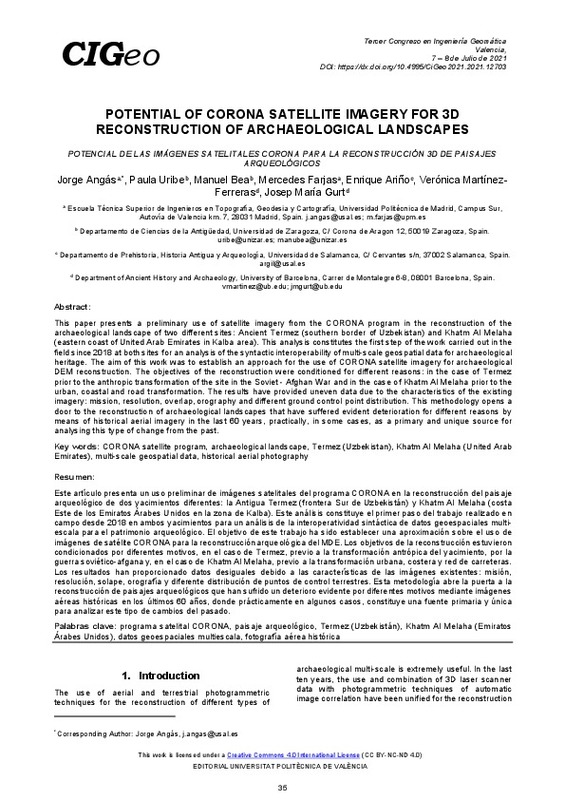 Angás, Jorge; Uribe, Paula; Bea, Manuel; Farjas, Mercedes; Ariño, Enrique; Martinez-Ferreras, Veronica; Gurt, Josep (Editorial Universitat Politècnica de València, 2021-10-01)[EN] This paper presents a preliminary use of satellite imagery from the CORONA program in the reconstruction of the archaeological landscape of two different sites: Ancient Termez (southern border of Uzbekistan) and Khatm ...
 -
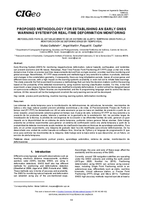 Qafisheh, Mutaz; Martin, Angel; Capilla, Raquel (Editorial Universitat Politècnica de València, 2021-10-01)[EN] Early Warning System (EWS) for monitoring megastructures deformation, natural hazards, earthquakes, and landslides can prevent economic and life losses. Nowadays, Real-Time Precise Point Positioning (RT-PPP) plays a ...
 -
 Javadi, Peyman; Lerma, José; García-Asenjo, Luis; Garrigues, Pascual (Editorial Universitat Politècnica de València, 2021-10-01)[EN] In recent years, the production of panoramic images has been boosted by the increasing use of digital photographiccameras and mobile phones. However, for highly demanding applications such as long-range deformation ...
 -
 Cerdá Bolinches, Artemio; Terol Esparza, Enric (Editorial Universitat Politècnica de València, 2021-10-01)[EN] High rates of soil erosion compromise sustainable agriculture. In rainfed agricultural fields, erosion rates several orders of magnitude higher than the erosion rates considered tolerable have been quantified. In ...
 -
 Alonso Pandavenes, Olegario Martin (Universitat Politècnica de València, 2024-02-15)[ES] Los deslizamientos son uno de los riesgos naturales que más trascendencia tiene en la actividad humana. En Ecuador, en época de lluvias (una de las dos estaciones del año), este tipo de eventos supone una de las mayores ...
 -
 Portela-Fernandez, Juan; Staller, Alejandra; Bejar-Pizarro, Marta (Editorial Universitat Politècnica de València, 2021-10-01)[EN] The El Salvador Fault Zone (ESFZ) comprises a set of a strike-slip faults, extending through the Central American Volcanic Arc within El Salvador, where the Cocos plate subducts under the Caribbean plate. These ...
Mostrando ítems 21-40 de 42

Universitat Politècnica de València. Unidad de Documentación Científica de la Biblioteca (+34) 96 387 70 85 · RiuNet@bib.upv.es
El contenido de este sitio está bajo una licencia Creative Commons Reconocimiento – No Comercial – Sin Obra Derivada (by-nc-nd), salvo que se indique lo contrario.
Los metadatos de este sitio están bajo una licencia Dominio Público.
