


Listar por palabra clave "Remote sensing"
RiuNet: Repositorio Institucional de la Universidad Politécnica de Valencia
- RiuNet repositorio UPV
- :
- Listar por palabra clave
JavaScript is disabled for your browser. Some features of this site may not work without it.
Buscar en RiuNet
Listar
Mi cuenta
Ayuda RiuNet
Admin. UPV
Listar por palabra clave "Remote sensing"
Mostrando ítems 41-60 de 223
-
 Lonneville, Britt; Vanhaeren, Nina; Vandenbulcke, Annelies; De Wulf, Alain; De Maeyer, Philippe (Editorial Universitat Politècnica de València, 2016-10-27)[EN] The goal of this work in progress is the virtual 3D reconstruction of one of the temples of the Ancient Ruins of Jiaohe (China). This site, considered as one of the key locations on the Silk Road, is slowly deteriorating ...
 -
 Briceño de Urbaneja, Idania; Sánchez-García, Elena; Pardo Pascual, Josep Eliseu; Palomar Vázquez, Jesús Manuel; Ugalde-Peralta, Raúl; Aguirre-Galaz, Catalina; Perez Martinez, Waldo; Vidal Páez, Paulina Javiera (Editorial Universitat Politècnica de València, 2021-10-01)[EN] Due to their oceanographic and climatic ecological characteristics, the coastal areas of the Valparaíso Region of Chile are of great importance for the country's tourist, economic, and environmental development. The ...
 -
 Pérez López, Sergio (Universitat Politècnica de València, 2020-05-13)[ES] Los satélites con instrumentos ópticos pasivos son ampliamente utilizados para la teledetección de la superficie terrestre, con aplicaciones que abarcan desde la cartografía hasta la monitorización de recursos naturales. ...
 -
 Patiño Moreno, Esther (Universitat Politècnica de València, 2021-01-07)[ES] Se analizará la representación de las parcelas agrícolas de los términos municipales de Llíria y Casinos en una serie temporal de imágenes Sentinel 2 para detectar de forma semiautomática el cultivo presente en cada ...
 -
Posada Fandiño, Heidy Bibiana (Universitat Politècnica de València, 2021-01-04)[ES] Este trabajo es una propuesta metodológica que utiliza la teledetección para el control de la superficie de cultivos a partir del análisis de información de imágenes Sentinel 2 Nivel 2A, adquiridas desde la colección ...
-
 Perea-Ardila, M. A.; Oviedo-Barrero, F.; Leal-Villamil, J. (Universitat Politècnica de València, 2019-06-27)[EN] Mangroves are plant communities of high ecological and economic importance for coastal regions. This investigation provides a methodology for mapping Mangrove forests through remote sensing images in a semidetail scale ...
 -
 Lee, Ming-Chun (Editorial Universitat Politècnica de València, 2018-04-20)[EN] GIS has been an e振ective tool to study urban form. However, as its own ield, GIS has evolved in a rapid pace over the past decades. Recent developments in geospatial analytics and visualization technologies o振er new ...
 -
 Luczfalvy Jancsó, Andrea; Jonlet, Benoît; Hallot, Pierre; Poux, Florent; Hoffsummer, Patrick; Billen, Roland (Editorial Universitat Politècnica de València, 2016-10-27)[EN] During the past decade, the implementation of 3D visualization and Geographic Information System (GIS) in archaeological research has increased and is now well established. However, the combination of these two factors ...
 -
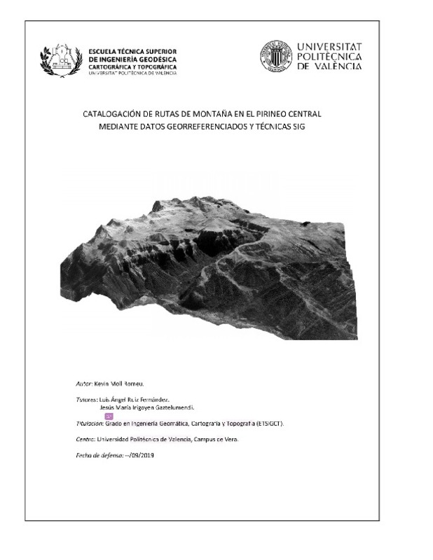 Moll Romeu, Kevin (Universitat Politècnica de València, 2019-09-25)[ES] Se realiza un inventario de rutas de montaña en la zona del Pirineo Central mediante estudio bibliográfico y de campo, adquisición, preprocesado y combinación de datos georreferenciados (MDT, imágenes Sentinel 2, ...
 -
 Cabezas-Rabadán, Carlos; Pardo Pascual, Josep Eliseu; Palomar-Vázquez, Jesús; Fernández-Sarría, Alfonso (Elsevier, 2019-11-15)[EN] Shoreline position can be efficiently extracted with subpixel accuracy frommid-resolution satellite imagery using tools as SHOREX. However, it is necessary to develop procedures for deriving descriptors of the beach ...
 -
 Cabezas-Rabadán, Carlos; Pardo Pascual, Josep Eliseu; Palomar-Vázquez, Jesús (MDPI AG, 2021-07)[EN] Sediment grain size is a fundamental parameter conditioning beach-face morphology and shoreline changes. From remote sensing data, an efficient definition of the shoreline position as the water-land interface may allow ...
 -
 Patiño Quinchía, Jorge Eduardo (Universitat Politècnica de València, 2016-01-07)[EN] The first part of this work reviews the potential applications of satellite remote sensing to regional science research in urban settings. The availability of satellite remote sensing data has increased significantly ...
 -
 Borràs, J.; Delegido, J.; Pezzola, A.; Pereira, M.; Morassi, G.; Camps-Valls, G. (Universitat Politècnica de València, 2017-06-20)[EN] Sentinel-2 (S2), a new ESA satellite for Earth observation, accounts with 13 bands which provide high-quality radiometric images with an excellent spatial resolution (10 and 20 m) ideal for classification purposes. ...
 -
 Miralles Ballester, Marc (Universitat Politècnica de València, 2019-11-12)[CA] La teledetecció s'ha convertit en les últimes dècades en una eina imprescindible en nombrosos àmbits de la nostra societat, i en concret, en l’estudi, investigació, gestió de la superfície terrestre. Per al cas que ...
 -
 Rodríguez-Valero, M. I.; Alonso-Sarria, F. (Universitat Politècnica de València, 2019-06-27)[EN] This work presents a cartography of land uses in the Segura Hydrographic Demarcation obtained by classifying 2017 Landsat 8 images. The classification was carried out using two classifiers: Maximum Likelihood (ML) and ...
 -
 Valero Cerdá, José Ignacio (Universitat Politècnica de València, 2021-01-25)[ES] Desarrollo de un cojín inteligente con sensores de presión, temperatura y humedad cuya información la recogerá un microcontrolador y la enviara a un sistema empotrado conectado a Internet. El sistema deberá soportar ...
 -
 Montes Robles, Roberto; Moragues Pons, María Esperanza; Vivancos Bono, José Luís; Ibáñez Civera, Francisco Javier; Fraile Muñoz, Rubén; Martínez Mañez, Ramón; García Breijo, Eduardo (Elsevier, 2015-11)[EN] This paper presents an electronic system for the automatic detection of hazardous gases. The proposed system implements colorimetric sensing algorithms, thus providing a low-cost solution to the problem of gas sensing. ...
 -
 Parthenios, Panagiotis; Androulaki, Theano; Gereoudaki, Evangelia; Vidalis, Giorgos (Editorial Universitat Politècnica de València, 2016-10-27)[EN] The use of 3D digitization and modelling in documenting heritage sites has increased significantly over the past few years. This paper presents the process of a monument’s virtual 3D reconstruction using Structure ...
 -
 Pecci, Antonio (Editorial Universitat Politècnica de València, 2016-10-27)[EN] In recent years we have witnessed to a great change in the archaeological and architectural relief due to the introduction of the laser scanner (Böhler 2006; Vosselman and Maas 2010) and to the improvement of the ...
 -
 Araneda-Cabrera, Ronnie J.; Bermúdez, María; Puertas, Jerónimo; Penas, Víctor (Universitat Politècnica de València, 2022-07-29)[EN] Drought is a natural phenomenon that affects socio-economic and environmental systems, so monitoring it is crucial to minimize its impacts. In Mozambique, in southern Africa, 70% of the population depends on agriculture ...
Mostrando ítems 41-60 de 223

Universitat Politècnica de València. Unidad de Documentación Científica de la Biblioteca (+34) 96 387 70 85 · RiuNet@bib.upv.es
El contenido de este sitio está bajo una licencia Creative Commons Reconocimiento – No Comercial – Sin Obra Derivada (by-nc-nd), salvo que se indique lo contrario.
Los metadatos de este sitio están bajo una licencia Dominio Público.
