JavaScript is disabled for your browser. Some features of this site may not work without it.
Buscar en RiuNet
Listar
Mi cuenta
Estadísticas
Ayuda RiuNet
Admin. UPV
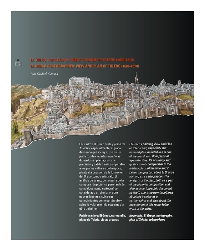
EL GRECO CARTÓGRAFO: VISTA Y PLANO DE TOLEDO (1608-1614)
Mostrar el registro sencillo del ítem
Ficheros en el ítem
| dc.contributor.author | Calduch Cervera, Juan
|
es_ES |
| dc.date.accessioned | 2013-01-25T11:43:27Z | |
| dc.date.available | 2013-07-01T22:30:43Z | |
| dc.date.issued | 2012-06-30 | |
| dc.identifier.issn | 1133-6137 | |
| dc.identifier.uri | http://hdl.handle.net/10251/19048 | |
| dc.description.abstract | [EN] El Greco¿s painting View and Plan of Toledo and, especially, the outlined plan included in it is one of the first drawn floor plans of Spanish cities. Its accuracy and quality is only comparable to the military plans of the time and it raises the question about El Greco¿s training as a cartographer. The analysis of the plan, both as a part of the pictorial composition and also as a cartographic document by itself, opens up new hypothesis about his training as a cartographer and also about the assessment of this remarkable work of the artist. | es_ES |
| dc.description.abstract | [ES] El cuadro del Greco Vista y plano de Toledo y, especialmente, el plano delineado que incluye, uno de los primeros de ciudades españolas dibujados en planta, con una precisión y calidad sólo comparable a los planos militares de la época, plantea la cuestión de la formación del Greco como cartógrafo. El análisis del plano, como parte de la composición pictórica pero también como documento cartográfico considerado en sí mismo, abre nuevas hipótesis sobre sus conocimientos como cartógrafo y sobre la valoración de esta singular obra del pintor. | es_ES |
| dc.language | Español | es_ES |
| dc.language | Inglés | |
| dc.publisher | Editorial Universitat Politècnica de València | es_ES |
| dc.relation.ispartof | EGA. Revista de Expresión Gráfica Arquitectónica | |
| dc.rights | Reserva de todos los derechos | es_ES |
| dc.subject | El greco | es_ES |
| dc.subject | Cartografía | es_ES |
| dc.subject | Plano de toledo | es_ES |
| dc.subject | Vistas urbanas | es_ES |
| dc.subject | Cartography | es_ES |
| dc.subject | Urban views | es_ES |
| dc.subject | Plan of toledo | es_ES |
| dc.title | EL GRECO CARTÓGRAFO: VISTA Y PLANO DE TOLEDO (1608-1614) | es_ES |
| dc.title.alternative | EL GRECO CARTOGRAPHER: VIEW AND PLAN OF TOLEDO (1608-1614) | es_ES |
| dc.type | Artículo | es_ES |
| dc.date.updated | 2013-01-25T10:48:58Z | |
| dc.identifier.doi | 10.4995/ega.2012.1359 | |
| dc.rights.accessRights | Abierto | es_ES |
| dc.description.bibliographicCitation | Calduch Cervera, J. (2012). EL GRECO CARTÓGRAFO: VISTA Y PLANO DE TOLEDO (1608-1614). EGA. Revista de Expresión Gráfica Arquitectónica. 17(19):68-77. https://doi.org/10.4995/ega.2012.1359 | es_ES |
| dc.description.accrualMethod | SWORD | es_ES |
| dc.relation.publisherversion | https://doi.org/10.4995/ega.2012.1359 | es_ES |
| dc.description.upvformatpinicio | 68 | |
| dc.description.upvformatpfin | 77 | |
| dc.description.volume | 17 | |
| dc.description.issue | 19 | |
| dc.identifier.eissn | 2254-6103 | |
| dc.description.references | CRESPO SANZ, Antonio, 2005, "Un mapa olvidado: el Atlas de El Escorial" (pp. 59-89), CT Catastro, octubre, 2005. | es_ES |
| dc.description.references | Díez Del Corral GARNICA, Rosario, 1987, Arquitectura y mecenazgo. La imagen de Toledo en el Renacimiento, Madrid, Alianza Forma. | es_ES |
| dc.description.references | Martínez-Burgos GARCÍA, Palma, 2004, El Greco: el pintor humanista, obra completa, Alcobendas, LIBSA. | es_ES |


